Back to Outdoors
easy2 hours east on CA-178
National Park of Extremes & Wonder
Death Valley National Park
HikingCampingPhotographyStargazing
Park Size3.4 million acres
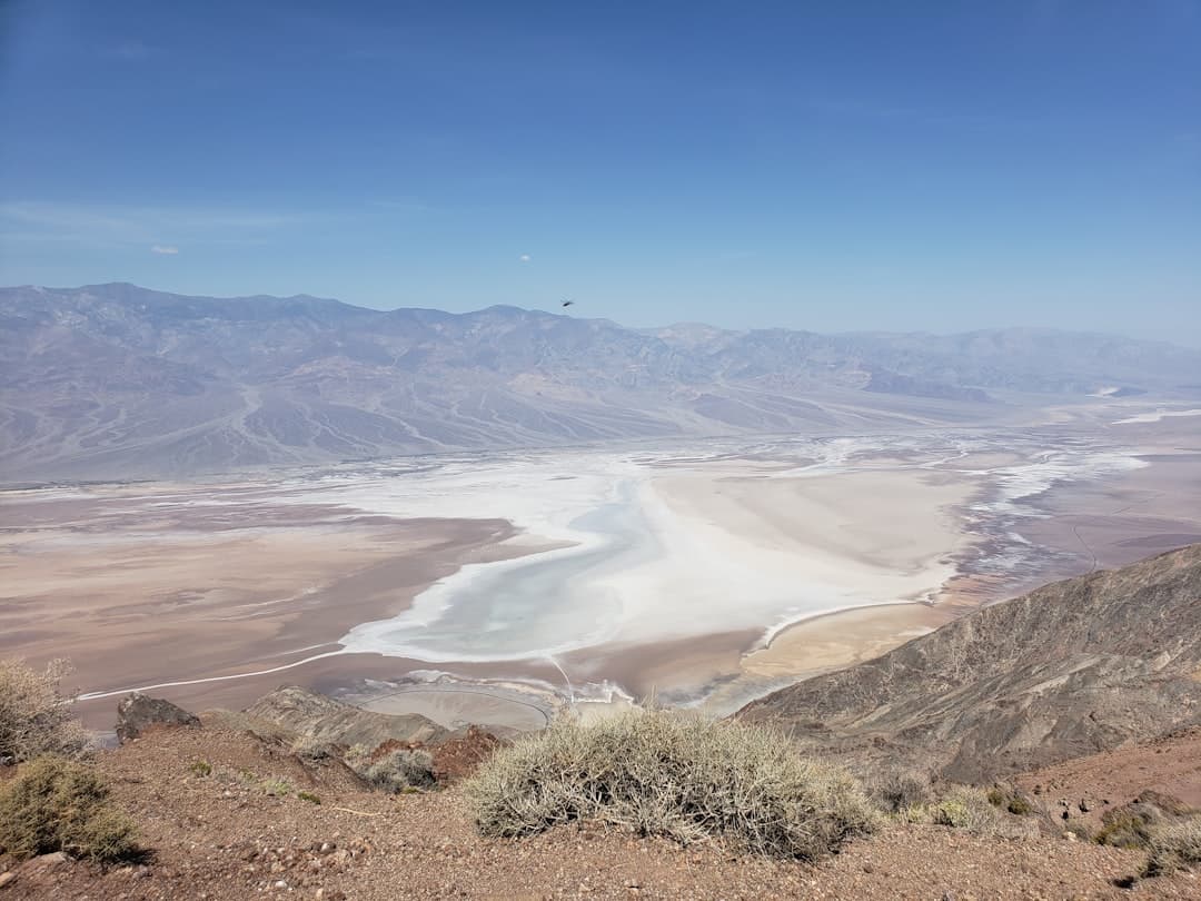
Lowest Point-282 ft (Badwater Basin)
Highest Point11,049 ft (Telescope Peak)
Record Temp134°F (1913)
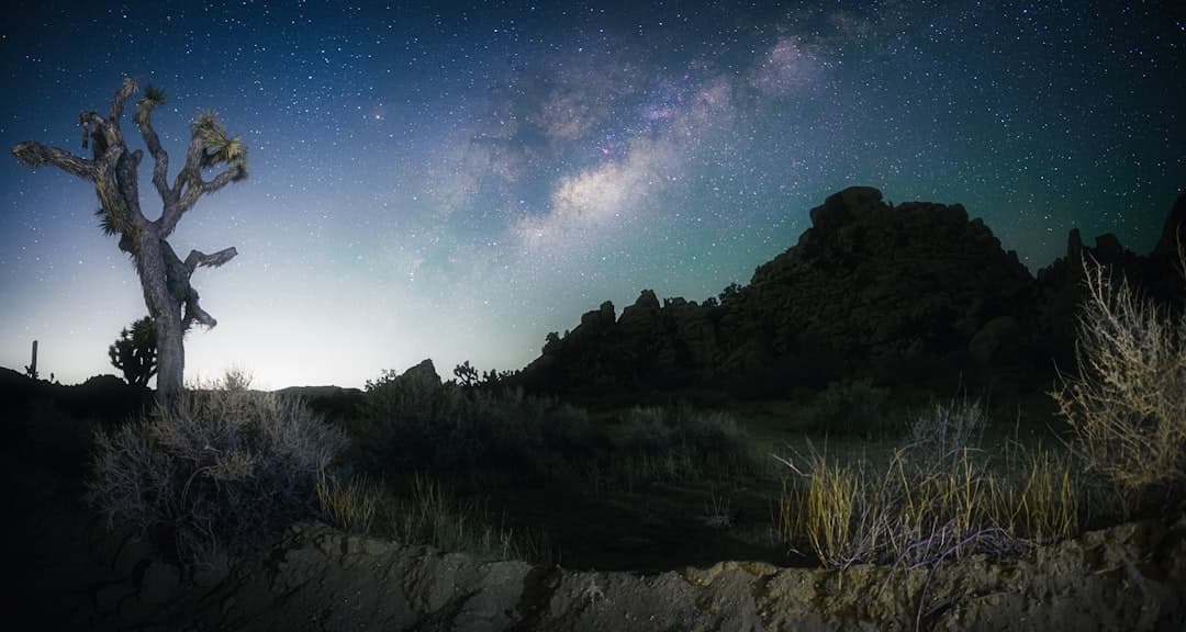
Dark Sky StatusGold Tier
Overview
Death Valley National Park is the largest national park in the contiguous United States, covering over 3.4 million acres of some of the most extreme and beautiful terrain on Earth. Located just two hours east of Ridgecrest, the park is a land of superlatives — it contains the lowest point in North America (Badwater Basin at 282 feet below sea level), holds the record for the highest reliably recorded air temperature on Earth (134 degrees Fahrenheit in 1913), and yet rises to over 11,000 feet at Telescope Peak, where snow falls in winter.
The landscapes within the park are staggeringly diverse. The Mesquite Flat Sand Dunes near Stovepipe Wells look like they belong in the Sahara. Zabriskie Point offers a sunrise panorama over ancient lake sediments eroded into an alien badlands. Artist's Drive winds through hills painted in shades of green, purple, red, and gold by mineral deposits. Titus Canyon provides a dramatic one-way drive through a narrow desert gorge. And at Badwater Basin, you can walk on a vast salt flat that stretches to the horizon, shimmering in the desert light.
Death Valley was designated an International Dark Sky Park with Gold Tier status, making it one of the best places in the world for stargazing. The park is most visited from November through March, when temperatures are pleasant for hiking and sightseeing. Summer visits are dangerous — temperatures routinely exceed 120 degrees Fahrenheit — but adventurous visitors who prepare properly can experience an eerie solitude as one of the few people in this vast landscape.
Things to Do
Badwater Basin Walk
Walk out onto the vast salt flats at the lowest point in North America. The polygon-shaped salt formations and distant mountain backdrop create unforgettable photographs.
Zabriskie Point Sunrise
Arrive before dawn at this iconic overlook to watch the first light paint the ancient lake sediments in gold and amber. One of the most photographed sunrises in the West.
Mesquite Flat Sand Dunes
Explore these accessible dunes near Stovepipe Wells, where wind-sculpted ridgelines and star dune formations create a miniature Sahara experience.
Titus Canyon Drive
A 27-mile one-way dirt road through a dramatic narrow canyon with petroglyphs, ghost towns, and geological wonders. High clearance vehicle required.
Artist's Drive
A 9-mile scenic loop through hills painted in vibrant greens, purples, reds, and golds by volcanic mineral deposits. Best in afternoon light.
Stargazing at Night
As a Gold Tier Dark Sky Park, Death Valley offers some of the darkest skies in America. The Milky Way is visible in stunning detail on moonless nights.
Highlights
Badwater Basin — lowest point in North America at 282 feet below sea levelZabriskie Point — iconic sunrise panorama over eroded badlandsMesquite Flat Sand Dunes — towering dunes near Stovepipe WellsTitus Canyon — dramatic one-way drive through a narrow gorgeInternational Dark Sky Park with Gold Tier statusArtist's Drive — colorful mineral-painted hillsLargest national park in the contiguous US (3.4 million acres)
Getting There
Drive Time
2 hours east on CA-178
Directions
Head east from Ridgecrest on CA-178 through Trona and over the Panamint Range. Enter the park via the Panamint Springs or Emigrant Pass entrances.
Details
Best Season
November through March — summer temperatures are dangerously hot
Fee
$35/vehicle for a 7-day pass; $55 for annual pass
Difficulty
easy
Dog Friendly
No
Tips & Safety
- Never visit in summer without extensive preparation — temperatures routinely exceed 120 degrees
- Carry at least 1 gallon of water per person per day, plus extra for your vehicle
- Gas stations are extremely limited — fill up in Ridgecrest or Trona before entering
- Cell phone service is nonexistent in most of the park
- Check road conditions before driving to remote areas — flash floods can wash out roads

Explore more outdoor destinations near Ridgecrest