Back to Outdoors
easy3 hours southeast
Desert Wonderland
Joshua Tree National Park
ClimbingHikingCampingPhotographyStargazing
Park Size~800,000 acres
Climbing Routes8,000+
Elevation Range536 to 5,814 ft
Established1994 (National Park)
EcosystemsMojave + Colorado Desert
Overview
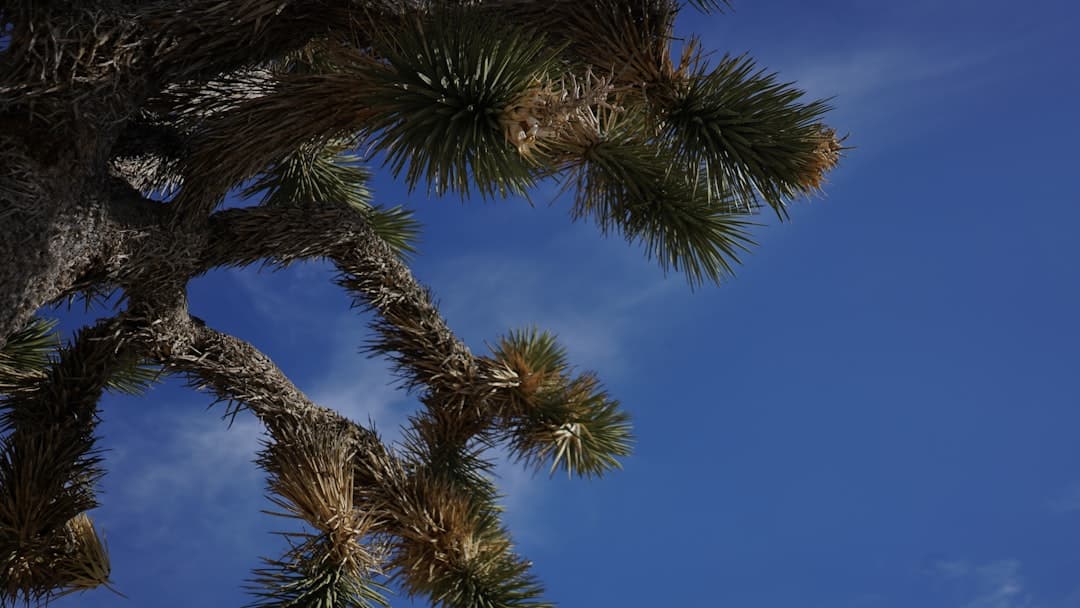
Joshua Tree National Park sits at the intersection of two distinct desert ecosystems — the higher, cooler Mojave Desert to the west and the lower, hotter Colorado Desert to the east. Named for the distinctive Joshua trees (Yucca brevifolia) that dot the landscape with their twisted, alien-looking limbs, the park covers nearly 800,000 acres of boulder-strewn desert that draws rock climbers, hikers, photographers, and stargazers from around the world. Located about 3 hours southeast of Ridgecrest, it makes for an excellent day trip or weekend adventure.
The park's most iconic feature is its dramatic rock formations — massive piles of monzogranite boulders, some as tall as buildings, that have been weathered into fantastic shapes by millions of years of erosion. These formations make Joshua Tree one of the world's premier rock climbing destinations, with over 8,000 documented climbing routes ranging from beginner-friendly face climbs to cutting-edge technical routes. Even non-climbers are drawn to scramble among the boulders, exploring the hidden valleys and natural corridors between the formations.
Beyond the rocks and Joshua trees, the park offers diverse desert landscapes including the surreal Cholla Cactus Garden, where thousands of teddy bear cholla cacti create a golden carpet at sunset; the historic Keys Ranch, a preserved desert homestead; and vast wilderness areas accessible only on foot. The park's dark skies rival those near Ridgecrest, and ranger-led night sky programs draw astronomy enthusiasts throughout the cooler months.
Things to Do
Rock Climbing & Bouldering
Over 8,000 climbing routes make Joshua Tree one of the top climbing destinations on Earth. Hidden Valley and the Hall of Horrors are popular areas for all skill levels.
Hike to Ryan Mountain
A 3-mile round trip hike to one of the best viewpoints in the park at 5,457 ft. The panoramic summit view encompasses the Pinto Basin, Lost Horse Valley, and distant mountain ranges.
Cholla Cactus Garden at Sunset
Walk the short boardwalk trail through thousands of teddy bear cholla cacti that glow golden in the late afternoon light. One of the most photographed spots in the park.
Keys View Panorama
Drive to this 5,185-foot viewpoint for sweeping views across the Coachella Valley, Salton Sea, San Andreas Fault, and on clear days, Signal Mountain in Mexico.
Skull Rock Trail
An easy 1.7-mile loop past the park's most famous rock formation — a boulder eroded into the shape of a skull — plus many other whimsical shapes.
Highlights
Iconic Joshua trees and boulder-strewn landscapesWorld-class rock climbing — over 8,000 routesTwo desert ecosystems — Mojave and Colorado deserts meet hereCholla Cactus Garden — surreal at sunsetKeys View panorama from 5,185 ft — views to the Salton Sea and beyondExcellent dark sky stargazing and ranger programsHistoric Keys Ranch desert homestead tours
Getting There
Drive Time
3 hours southeast
Directions
Head south on US-395 to CA-14, then take CA-58 east and connect to CA-247 south through Lucerne Valley, then east on CA-62 to the park's north entrance at Twentynine Palms.
Details
Best Season
October through May — summer temperatures exceed 100 degrees
Fee
$30/vehicle for a 7-day pass
Difficulty
easy
Dog Friendly
No
Tips & Safety
- Enter from the north (Twentynine Palms) entrance for the most iconic Joshua tree landscapes
- Bring more water than you think — the desert air dehydrates quickly
- Campgrounds fill up on spring weekends — reserve months in advance or arrive early
- Watch where you sit and put your hands — cacti, scorpions, and rattlesnakes are present
- The park has no food, gas, or lodging — stock up in Twentynine Palms or Joshua Tree village

Explore more outdoor destinations near Ridgecrest